Tibetet Segítő Társaság Sambhala Tibet Központ
Tibet Support Association Sambhala Tibet Center
székhely / telephely H-Budapest I. Attila út 123..
(00-36) 70 431 9343 (00-36)70 944 0260 (06-1)782 7721
sambhala@tibet.hu www.tibet.hu tibetpress.info
Facebook/Sambhala Tibet Központ Facebook/Tibett Segítő Társaság
MagnetBank/ 16200010-00110240
IBAN/HU94 16200010 00110240 00000000 SWIFT/HBWEHUHB
(1%) adószám/ 18061347-1-41
nyitva tartás/hétköznap 12.00-20.00 hétvégén előadás függő
- Programok-Epocha
- Tibet Mozi
- TibetPress
- Galéria
- Mantrák
- Potala/riportok
- Könyvtár
- Dharma bolt
- Támogatás
- Fórum
- Videók
- Meditációk
- Nem Meditáció
- Tibeti Jóga
- Linkek
- Kapcsolat
- JóBarátok
- Sambhala
- Imamalom
- Buddhista közösségek
Közreműködő Bank
» tibeti művészet» lapszemle.hu» thetibetpost.com» eastinfo.hu» rangzen.net» ChoegyalTenzin» tibet.net» phayul.com» DalaiLama.com» vilaghelyzete.blogspot.com» Videók» Linkek» TibetiHírek» Szerkesztőség
Tibet Decolonized/ENG
2019. május 2./The Dekolonial Atlas/TibetPress
eredeti cikk
Here at the Decolonial Atlas, we’ve been working to challenge imperial narratives wherever they exist in cartography. Recently though, we’ve heard from our community that the Atlas has not presented enough material about non-Western imperialism. Addressing that, we decided to attempt a decolonized map of བོད་ (Bod, commonly known as Tibet in the West), labelled in བོད་སྐད་ (Bod Skad, the Tibetan language), and acknowledging Bod as a distinct territory from China which has occupied the country since 1950. Under Chinese occupation, Bod has been wiped off the map, divided up, renamed, and incorporated into Chinese provinces. By creating a map that subverts those efforts, we can more easily visualize a free and independent Bod.
In this map, the area in white represents “Ethnic Tibet,” the region where the བོད་པ་ (Bod Pa, Tibetan people) have historically predominated, as opposed to the smaller བོད་རང་སྐྱོང་ལྗོངས། (Bod Rang Skyong Ljongs, Tibet Autonomous Region) or “Political Tibet,” a modern jurisdiction of China. If Bod achieved independence, it would be the world’s tenth largest country by area. Traditionally, Bod has three main regions: ཨ༌མདོ (Amdo), ཁམས་ (Kham), and དབུས་གཙང་ (Ü-Tsang). The latter forms the bulk of Bod Rang Skyong Ljongs, and has historically been independently ruled from its capital, ཁྲིན་ཀོན་ཆུས། (Lhasa, literally ‘Place of gods’). Amdo and Kham, being further east and in closer proximity to China than Lhasa, have historically achieved less autonomy despite persistent resistance. Following the 1959 Tibetan Uprising in which some 87,000 Bod Pa died revolting against Chinese occupation, the Dalai Lama and others fled across the border to establish the བོད་མིའི་སྒྲིག་འཛུགས་ (Bod Mi’i Sgrig ‘Dzugs, Tibetan Government in Exile) in རྡ་རམ་ས་ལ། (Dharamshala India), where they have continued to fight for the Bod Pa for the past 60 years.
The word ‘Tibet’ made its way into English in the 18th century from Turkic-speaking peoples in Western and Central Asia who called this region Töbäd (Literally ‘The heights’). Indeed, Bod is often called ‘the roof of the world.’ The world’s highest mountain, ཇོ་མོ་གླང་མ (Chomolungma, Mount Everest), and the ཧི་མ་ལ་ཡ (Himalayas) form Bod’s southern frontier. Supplying water to billions of people, many of Asia’s great rivers find their source in Bod, including the ཡར་ཀླུང་གཙང་པོ་ (Yar Klung Gtsang Po, Brahmaputra), གླང་ཆེན་ཁ་བབས། (Glang Chen Kha Babs, Ganges), སེང་གེ་ཁ་འབབ (Seng Ge Kha ‘Bab, Indus), ཟླ་ཆུ། (Zla Chu, Mekong), རྒྱལ་མོ་རྔུལ་ཆུ། (Rgyal Mo Rngul Chu, Salween), འབྲི་ཆུ (‘Bri Chu ‘river of the female yak’, Yangtze), and རྨ་ཆུ། (Rma Chu ‘river of the peacock’, Yellow).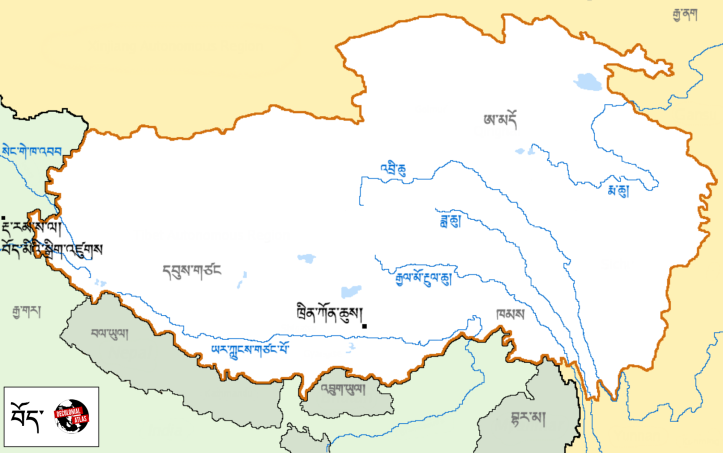
བོད་ (Bod, Tibet) in བོད་སྐད་ (Bod Skad, Tibetan) by Jordan Engel.
བོད་ (Bod, Tibet) in བོད་སྐད་ (Bod Skad, Tibetan) and English by Jordan Engel.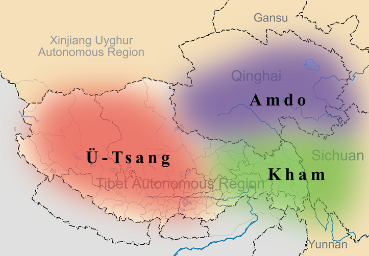
Traditional regions of བོད་ (Bod, Tibet), from Wikipedia.
These maps, except for the last one, were made by Jordan Engel. They can be reused under the Decolonial Media License 0.1.