Tibetet Segítő Társaság Sambhala Tibet Központ
Tibet Support Association Sambhala Tibet Center
székhely / telephely H-Budapest I. Attila út 123..
(00-36) 70 431 9343 (00-36)70 944 0260 (06-1)782 7721
sambhala@tibet.hu www.tibet.hu tibetpress.info
Facebook/Sambhala Tibet Központ Facebook/Tibett Segítő Társaság
MagnetBank/ 16200010-00110240
IBAN/HU94 16200010 00110240 00000000 SWIFT/HBWEHUHB
(1%) adószám/ 18061347-1-41
nyitva tartás/hétköznap 12.00-20.00 hétvégén előadás függő
- Programok-Epocha
- Tibet Mozi
- TibetPress
- Galéria
- Mantrák
- Potala/riportok
- Könyvtár
- Dharma bolt
- Támogatás
- Fórum
- Videók
- Meditációk
- Nem Meditáció
- Tibeti Jóga
- Linkek
- Kapcsolat
- JóBarátok
- Sambhala
- Imamalom
- Buddhista közösségek
Közreműködő Bank

» Retro» Tibeti művészet» Interjú» Levelek» Tibet Press» Tibet Press English» Dharma Press» Human Rights» Világ» Kína» Magyar» Ujgur» Belső-Mongólia » KőrösiCsoma» Élettér» Határozatok» Nyilatkozatok» tibeti művészet» lapszemle.hu» thetibetpost.com» eastinfo.hu» rangzen.net» ChoegyalTenzin» tibet.net» phayul.com» DalaiLama.com» vilaghelyzete.blogspot.com» Videók» Linkek» TibetiHírek» Szerkesztőség
Kína szerint a Brahmaputrát elsárosító földrengés nem az alagútépítés következménye
2017. december 28./Phayul.com/TibetPress
Jelenleg csak angolul olvasható. Magyarul később.
eredeti cikk
By Tenzin Dharpo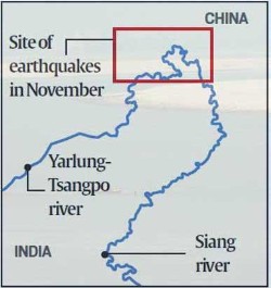 DHARAMSHALA, Dec. 28: China on Wednesday hit back at claims by Indian media that muddy waters of the Brahmaputra originating from occupied Tibet and flowing through Arunachal Pradesh in India was not caused by its tunneling projects but by earthquakes in Tibetan areas earlier in November.
Chinese Foreign Ministry spokesperson Hua Chunying said that a 6.9-magnitude earthquake in mid-November hit the area near Mainling County in Tibet causing turbidity in the lower reaches of the river. She said, "After the earthquake, we monitored the water quality of the Yarlung Zangpo (Tibetan name for Brahmaputra) and the results showed that it met the standards of Class III water."
"It is caused by natural factors. It is not a manmade accident. I noticed that Indian professional authorities have made an analysis and clarified," she said, referring to reports that the lakes were formed by the landslides by two researchers from Bengaluru-based National Centre for Biological Sciences (NCBS) and Ashoka Trust for Research in Ecology and the Environment (ATREE). The Indian research results show that quake-induced landslides on the river continued for over three weeks, and resulted in turbidity in the lower reaches of the Siang river (local name) in Arunachal Pradesh.
“There is no foul play involved. However, landslide-induced turbidity usually subsides within a week. So we are examining the situation through satellite images as the affected area is not within our territory. We will get a clearer picture soon,” Pradeep Kumar, member (river management), Central Water Commission, told The Indian Express.
Indian researchers also cited images captured by the European Space Agency’s Sentinel-2 satellite on December 10 which captured the landslide in progress as well as blockages of the Yarlung-Tsangpo river by debris at three locations in the Bayi district, Nyingchi County in occupied Tibet.
Experts fear of the three lakes caused by the landside merging into one and giving way to floods in downstream areas, similar to that in 2000 when a massive landslide on the Yigong-Tsangpo created a 90-metre deep natural reservoir across 2.5 square kilometres which later caused flooding of the Brahmaputra and destroyed over 50 villages in Arunachal Pradesh and Assam in India.
Hua Chunying from China’s FM yesterday said that her government will maintain communication with India on dealing with the lakes caused by landslide on the Yarlung Tsangpo.